• Skip to Content
  • Skip to Navigation
  • Skip to Footer
  • Skip to Cookie Settings
Wipro Logo
What We Do
What We Do
Services
Applications Artificial Intelligence Business Process Services Cloud Consulting Cybersecurity Data & Analytics Digital Experiences Engineering Sustainability
Industries
Banking & Financial Services
›
Banking Capital Markets Insurance
Comms, Media & Information Services
›
Communications Media & Info Services
Consumer
›
Consumer Packaged Goods Education Professional Services Public Sector Retail Travel, Transportation, Hospitality and Services
Energy, Manufacturing and Resources
›
Aerospace & Defense Automotive Engineering Construction Operations Industrial & Process Manufacturing Natural Resources Oil & Gas Utilities
Hi-Tech
›
Consumer Electronics Semiconductors
Technology Products and Services
›
Network & Edge Providers
Healthcare Life Sciences & Pharma Medical Devices Platforms, Software Products and Gaming
Services
Applications Artificial Intelligence Business Process Services Cloud Consulting Cybersecurity Data & Analytics Digital Experiences Engineering Sustainability
Industries
Banking & Financial Services
Banking Capital Markets Insurance
Comms, Media & Information Services
Communications Media & Info Services
Consumer
Consumer Packaged Goods Education Professional Services Public Sector Retail Travel, Transportation, Hospitality and Services
Energy, Manufacturing and Resources
Aerospace & Defense Automotive Engineering Construction Operations Industrial & Process Manufacturing Natural Resources Oil & Gas Utilities
Hi-Tech
Consumer Electronics Semiconductors
Technology Products and Services
Network & Edge Providers
Healthcare Life Sciences & Pharma Medical Devices Platforms, Software Products and Gaming
What We Think
About Wipro
About Wipro
About Us Analyst Reports Awards and Recognitions Case Studies Corporate Sustainability Events
Inclusion and Belonging Investors Leadership Locations News Partner Ecosystem
Privacy at Wipro Supplier Diversity Wipro Innovation Network Wipro Ventures Wipro Wellbeing
About Us Analyst Reports Awards and Recognitions Case Studies Corporate Sustainability Events
Inclusion and Belonging Investors Leadership Locations News Partner Ecosystem
Privacy at Wipro Supplier Diversity Wipro Innovation Network Wipro Ventures Wipro Wellbeing
Careers
Contact Us
Wipro IG Linkedin Wipro

Europe ›

Europe Sub Menu Opened
  • Benelux en
  • Europe en | de
  • Germany & Austria en | de
  • Nordic en
  • Southern Europe en | fr
  • United Kingdom & Ireland en

Americas ›

Americas Sub Menu Opened
  • Brazil en | pt
  • Canada en | fr
  • Latam en
  • Mexico en | es
  • United States en

Asia & Pacific ›

Asia & Pacific Sub Menu Opened
  • Asean en
  • Australia & New Zealand en
  • China en
  • Japan ja
  • Korea en
  • Taiwan en

India & Middle East ›

India & Middle East Sub Menu Opened
  • India en
  • Middle East en

Africa

< Business Process Services

Geo-Spatial Information Systems

download.png favorite page unfavorite page share icon
download.png favorite page unfavorite page

Geo-Spatial Information Systems

microsites_play_icon
X

microsites_play_icon
popup-image

A trusted leader in providing global geographic information maintenance and updation services

Wipro is the service provider of choice for GIS asset maintenance, data labelling, mapping, and map digitization services

Wipro has vast experience of 10 years as a trusted partner for global companies across varied spaces in GIS across more than 80 countries. We have successfully delivered over 15 engagements through more than 8,000 GIS experts across the world. We specialize in building grounds-up maps and covering different layers like lane navigation, drive coding, point of interest (POI), area of interest (AOI), addressing, street digitization & attribution, natural features (island & seas bodies), buildings, indoor maps, maps maintenance, and business data re-engineering. With a pool of over 200 quality and data management experts, Wipro has delivered:  
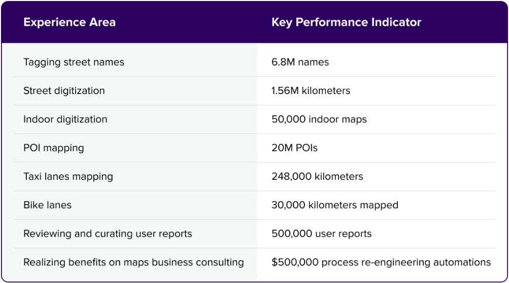
In addition, we possess significant expertise in managing GIS assets for key electricity, gas, water-sewage, and telecom players.

Recently, we have embarked on the next set of GIS requirements on creating and planning on building shelf space (like micro/macro space design planning and execution, display SKU planning, demarcation of area, space planning as per customer movement, visualization of front and rear view of the store, etc.) through GIS tools and creating planograms (store preparation and need based strategies, product SKU identification through 3D images visualized on RGIS, layout management, categorization of new display space, seasonal promotional area planning layout, etc.) for some of our retail customers.

Our data annotation and labelling services are designed for some of the premier autonomous car manufacturers and have established a strong pipeline of talent in this area.

End-to-end mapping and navigation expertise

Wipro's geospatial services include span creation, support, and maintenance to provide map and data services to leading companies. These geospatial services are used for navigation apps, ride-hailing, last mile, autonomous cars, 3D analysis, utility asset management, urban studies, and location analytics. Our geospatial services provide data of the highest accuracy to our customers, enabling a faster go-to-market and product monetization through our offerings such as base mapping, country readiness, indoor mapping, AOI/POI mapping, street road addressing, lane navigation, hyper mapping, street view field operations, etc.

With over 8,000 GIS associates engaged in our offshore delivery centers, we have delivered more than 25 million map editing hours to our global customers. Our GIS academy and Center of Excellence (CoE) are well equipped to provide quality skill set resources and best practices for operational excellence and high customer satisfaction.

Our various engagements in this space have provided our customers with the following benefits:

  • $15M savings passed to customers through process efficiencies gain and improvements
  • 18% increment in map data quality within two months
  • Less than 5% rework & faster country completion and launch to go live status
  • 20% reduction in manual processing
  • 30% efficiency gain through dynamic annotation automation
  • 20% gain in YoY efficiency with the proposed model of integrated curations

GIS asset maintenance of telecom/electric/gas/water network assets

Businesses constantly require capturing field changes accurately to improve their service efficiency. This includes spatial integration, approval management, field updates, updating internal asset databases for the telecom sector, electricity & gas, and water and sewage utility service companies.

These utility companies often face voluminous day-to-day last mile connectivity changes with new connections added, some connections discontinued, constant tracking of service and repair requests, maintaining minimal damage and interruptions to services in case of unforeseen circumstances, which can be reduced significantly if detailed GIS asset tracking is maintained on regular basis.

The following are the typical assets maintained under this service line:

  • Telecom management: Underground / overhead lines, OFC network, towers, stations, hubs, nodes, poles, routers, distribution panels, network termination devices, etc.
  • Electricity & gas management: Underground / overhead lines, transformers, substations, poles, valves & joints, complete network with last mile connectivity, meters
  • Water and sewer utility: Water storage tanks/reservoirs, city network lines, valves, meters, IC, treatment plants.

For more details on asset maintenance services, please click here.

AI/ML based data labelling services

AI/ML systems are ever-learning technologies, which largely work on a source database of multiple scenarios, based on which the system is able to intelligently analyze and take decisions for the future. This source database is a collection of millions of scenarios fed to the system in a well-labelled manner. This data labelling activity is technical in nature and usually requires human intervention to help the AI system learn better.

New AI/ML based arenas such as OVM infotainment systems for major car manufacturers, auto speed limits, object & image labelling, street view field operations, autonomous cars driving, etc. are all based on data labelling services. Data labelling can be of various types such as 2D,3D, 4D labelling, fused labelling, scenario labelling, PBR labeling, etc.

The key benefits for our customers through data labelling offering include:

  • 60M verified labelling in 2D
  • 4.5M labelling in 4D
  • 1.5 B data labelling objects and images
  • Over 750,000 videos reviewed in a month
  • Over 50,000 creators enrolled

Please feel free to connect with us to know more about our GIS offerings.

What We Think

Brochure: Wipro Geographic Information System

Utility network field changes across the country are voluminous and need to be updated

Building Stronger Deep Technologies Through Data Annotation

Data is a key component in leveraging deep technologies to significantly improve their operations and technology-based decision making. Accurate data labelling is essential for organizations to reap the benefits and secure their investments. .

Form Title

Business Process Services

Evolution of GIS: How Maps Have Progressed from a Mapping Pancake to a Soufflé

Since the inception of Geospatial Information Systems (GIS) in the late 1960s, there has been a considerable shift in customer expectations and capabilities.

Form Title

© 2025 Wipro
  • Disclaimer
  • Privacy
  • Modern Slavery Statement
  • X

    Share Icon
    popup-image

    Contact Wipro

    Please fill the required details to access the content

    loading.gif