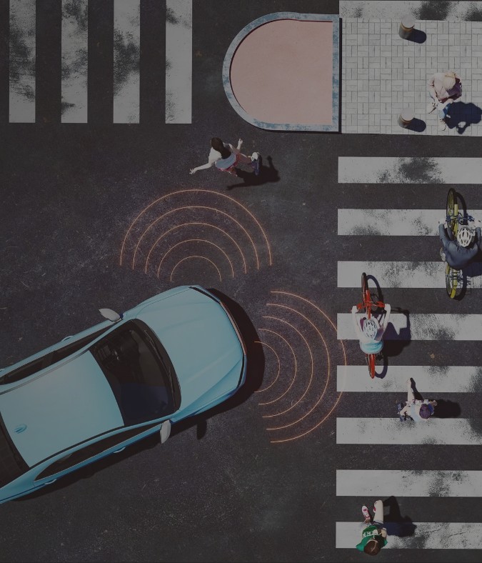
Autonomous mobility is transitioning from experimentation to a results driven era, where success is defined by the ability to deliver at scale with real-world safety, operational efficiency and regulatory alignment. Over the past decade, autonomous test fleets have logged hundreds of millions of miles across diverse cities and environments. In doing so, the industry has uncovered a critical insight: scaling autonomy is not limited by algorithms or sensors, but by the ability to validate perception, manage data quality, and prove safety consistently.

According to a McKinsey report, timelines for widespread Level 4 autonomy have adjusted to 2032, signaling a more pragmatic emphasis on readiness and risk mitigation. Competitive differentiation is increasingly driven by software maturity, data management discipline, and validation rigor. At the same time, the economic viability of shared autonomous fleets depends on automation and standardization. These outcomes are only achievable when perception systems are trained on accurate, verifiable, and auditable data.

Within this context, LiDAR‑powered AI‑enabled annotation is emerging as a strategic enabler by linking perception quality directly to time‑to‑market, cost efficiency and the scalability of autonomous mobility programs.

Why Scaling Autonomy Stalls and How Depth Data Changes the Equation

Despite continued advancements in core technologies, the path to large‑scale Level 4 deployment faces increasing scrutiny. The complexity of safety validation and regulatory approval grows non‑linearly as systems expand across cities and operating conditions. This places renewed focus on a foundational requirement: robust data quality, precise sensor calibration, and transparent auditability must anchor any effort to scale autonomous operations.

Operational realities reinforce this challenge. Shared autonomous fleets continue to operate under meaningful cost pressures. Improvements in utilization and efficiency depend not only on vehicle automation, but on industrializing data workflows like annotation, quality assurance, validation and retraining. Without scalable data operations, safety‑critical performance becomes harder to sustain, and operating costs rise rapidly.

As autonomous systems mature, value shifts away from hardware differentiation toward software intelligence, perception robustness, prediction accuracy, and validation confidence. High‑quality annotation is therefore not a downstream technical task, but a strategic differentiator. Organizations that apply the same rigor to data operations as they do to engineering and safety processes are better positioned to accelerate deployment, strengthen trust, and sustain long‑term performance.

Strategic Imperative for a LiDAR‑First Annotation Approach

Autonomous fleets generate continuous streams of multimodal data at scale. Among these inputs, LiDAR provides the most consistent and objective representation of spatial reality. Unlike monocular camera systems which can degrade under low light, glare, or partial occlusion, LiDAR captures depth‑accurate 3D point clouds independent of environmental conditions.

Importantly, LiDAR is not intended to replace camera systems, but to complement them. Within a sensor‑fusion architecture, LiDAR serves as a geometric anchor by stabilizing camera‑based semantic understanding and reducing ambiguity in complex scenes.

A LiDAR‑first approach to annotation offers several advantages:

1. Objective geometric truth: Time‑of‑flight measurements produce verifiable spatial data, ensuring consistent distance and orientation readings. This geometry provides a stable reference frame against which camera‑derived semantics can be aligned and validated.

2. High‑precision perception: Reliable depth supports accurate object segmentation, motion tracking, and self‑localization. When fused with camera inputs, depth improves semantic consistency and reduces uncertainty in dense or dynamic environments.

3. Foundation for sensor fusion: LiDAR depth acts as the stabilizing layer for integrating cameras, radar, and additional modalities. Anchoring fusion in geometry rather than appearance alone makes perception pipelines more predictable and resilient as systems scale.

4. Scalable accuracy: As fleets expand across cities and seasons, LiDAR‑anchored datasets minimize drift, ambiguity, and rework, helping camera‑semantic models maintain performance as operational diversity increases.

In this way, LiDAR becomes more than another sensor. It forms the backbone of a perception architecture built for reliability, repeatability, and scale.

What Next‑Generation LiDAR + AI Annotation Looks Like

Leading autonomous programs now integrate LiDAR’s depth geometry with camera‑based semantic context, enabling AI‑driven annotation workflows that move beyond object detection toward richer scene understanding.

Key characteristics include:

1. Depth‑Grounded Annotation Accuracy: Modern LiDAR annotation has evolved from 3D bounding boxes to point‑cloud semantic segmentation, allowing systems to understand not only object presence, but materiality and navigability. This enables distinctions—such as rigid curbs versus traversable vegetation—that are critical for safe maneuvering and emergency planning.

2. Automation‑Enabled Quality Assurance: Depth‑anchored 3D datasets underpin automated QA pipelines. Model‑assisted pre‑labeling and sequence propagation accelerate throughput while maintaining consistency across large and diverse datasets. Grounding QA in geometry rather than appearance helps preserve quality as volume and variability increase.

3. Downstream Intelligence Enablement: LiDAR‑rich datasets strengthen downstream tasks such as behavioral annotation, trajectory prediction and reinforcement learning from human feedback (RLHF). RLHF represents a shift from identifying what is present to shaping what is the appropriate action, allowing human judgment to encode social driving norms into the model’s decision logic.

Together, these capabilities enable perception and behavior models that are not only more accurate, but more aligned with real‑world driving complexity.

The Operational Realities: Scale, Standards and Responsible Data Stewardship

As autonomous mobility moves toward broader deployment, three operational realities become unavoidable:

1. Industrial‑Grade Scale: Centralized architectures shift complexity from vehicles to data preparation, storage, and validation. Automated annotation and QA are essential to controlling total cost of ownership as fleets grow.

2. Standardization for Interoperability: Modular technology stacks and decoupled hardware‑software models require disciplined interoperability standards. Without them, organizations risk vendor dependency, inconsistent performance, and high relabeling costs.

3. Governance and Ethical Stewardship: Transparent, auditable data lineages—spanning sensor inputs, calibration records, annotation histories, and decision traces—are increasingly baseline expectations for regulators and the public. Privacy‑by‑design must be embedded throughout the data lifecycle.

Grounding Autonomous Intelligence in High‑Integrity Data

The transition to Level 4 autonomy is no longer a race of hardware innovation. It is a test of disciplined data stewardship. As the industry advances toward the 2032 horizon, differentiation will be shaped by how rigorously perception systems are grounded in reality and how effectively decision logic reflects human judgment.

Anchoring perception in the objective spatial truth of LiDAR, while refining behavior through human‑centric reinforcement learning, transforms raw sensor streams into systems that are dependable, auditable, and scalable. In autonomous mobility, intelligence is not defined by what a model predicts in isolation, but by what high‑integrity data enables it to decide—consistently and under real‑world pressure.

About the Authors

Mohammed Shariff
General Manager & Practice Head, Geo Spatial Information Services (GSIS), Business Process Services

Mohammed Shariff is a senior business and delivery leader specializing in geospatial services, AI‑led operations, and large‑scale digital transformation. As Practice Head for GSIS, he partners with global enterprises to improve operational resilience, accelerate transformation, and deliver measurable outcomes across complex, high‑impact programs. With deep expertise in stabilizing mission‑critical engagements and managing operational risk, Mohammed helps organizations build scalable, future‑ready operating models across geospatial ecosystems through strong governance and technology‑driven execution.

Rakesh Sinha
Associate Vice President, Geo Spatial Information Services (GSIS), Business Process Services

Rakesh is a delivery and transformation leader with over 20 years of experience in geospatial services and AI‑led operations. He specializes in building strong partner ecosystems and delivering end‑to‑end geospatial solutions for global enterprises. Rakesh focuses on improving operational efficiency, strengthening governance, and scaling resilient service models across complex, high‑impact programs, helping clients reduce complexity and achieve measurable business outcomes.

Shaiwal Bhattacharya
Principal Consultant, Geo Spatial Information Services (GSIS), Business Process Services

Shaiwal is a Principal Consultant at Wipro specializing in AI data operations for autonomous vehicle programs. With over 11+ years of experience across program management, vendor ecosystems, and large-scale operational delivery, he leads initiatives focused on improving machine learning data quality, scaling annotation pipelines, and designing end-to-end operational frameworks that enable reliable datasets for autonomous driving systems.